

Get free consultation
Fill out the form and we will contact you
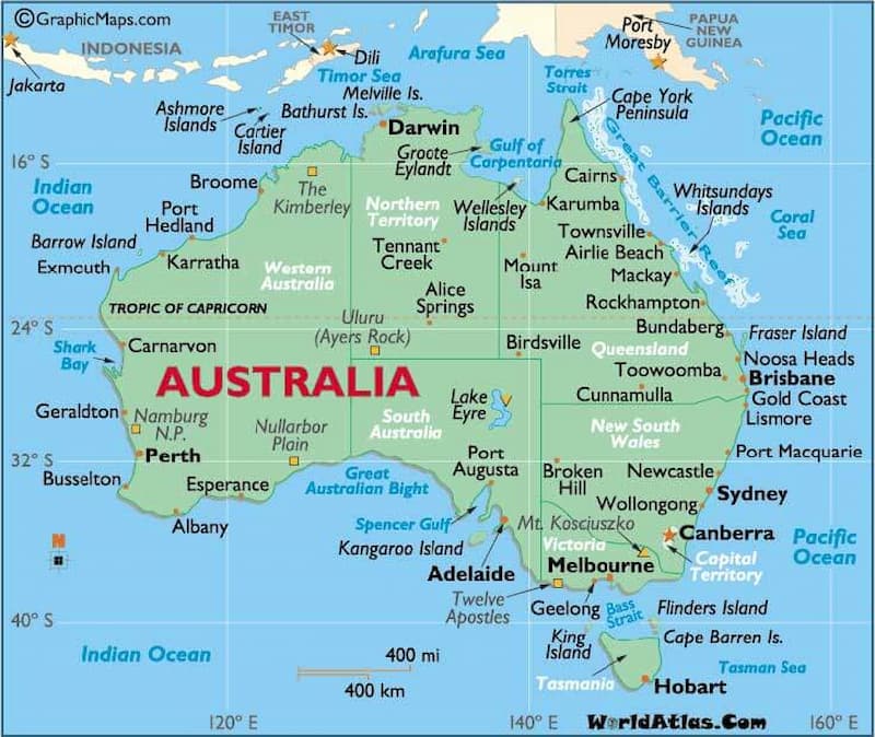
The map of Australia provides a wealth of useful information, such as its geographical location and the differences in time zones across continents. In addition, when exploring Australia, knowing how to read the map will help you determine directions and identify the destinations you want to visit. Follow this article with Quoctichthuhai.com to discover more valuable insights from the map of Australia.
Australia, also known as the Commonwealth of Australia, is a country surrounded by the Pacific Ocean, the Indian Ocean, and several large and small islands. Specifically:
The land area of Australia is 7.659 million km², with its territory completely surrounded by water. Due to its vast size and diverse natural landscapes, the country is known for its rich geographical features. The capital of Australia is Canberra, while Sydney is the largest city, characterized by low population density and a high average income per capita.
The map of Australia shows its vast land area, including both the mainland and maritime territories
Due to its large size, Australia is divided into three main time zones: Western Australia at +8, Central Australia at +9, and the Eastern states at +10. English is the primary language spoken here, alongside more than 200 other languages. Because of multicultural immigration, Australian English does not differ significantly in dialect compared to standard English.
By looking at the map of Australia, one can observe the distinct climate patterns across its territories. Given the country’s wide area, the weather varies greatly and is influenced by surrounding seas. In the north, closer to the Asian continent, the climate is tropical and pleasant. In the eastern states, the climate is cooler due to proximity to Antarctica, with four distinct seasons.
When viewing the map of Australia, you can see its main states along with their size and distribution:
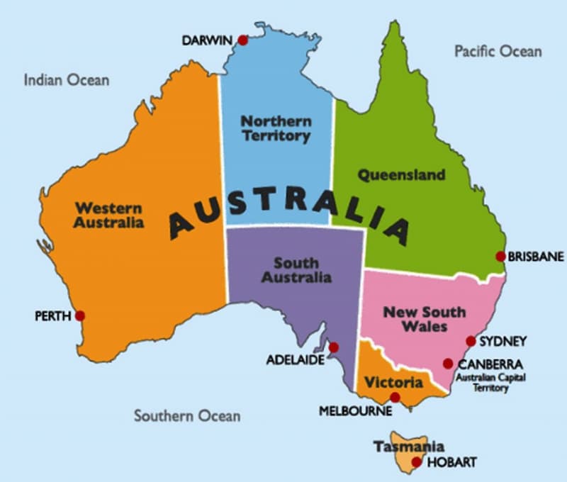
On the map, Australia is shown with six primary states, including:
Australia has 6 main states
New South Wales: The main city is Sydney, which has a high population density and is the country’s financial and economic hub, famous for the Sydney Harbour Bridge and the Opera House.
Victoria: The city of Melbourne is known as the cultural and sports center, with a vibrant atmosphere and diverse food festivals.
Tasmania: The city of Hobart is located on the large island to the south of Australia, featuring unspoiled nature and a temperate climate.
Queensland: The city of Brisbane is famous for the Great Barrier Reef, tropical climate, beautiful beaches, and is one of Australia’s top tourist destinations.
South Australia: The city of Adelaide is renowned for its fine wines and vineyards across semi-arid landscapes.
Western Australia: The city of Perth covers a vast area, rich in natural resources such as gold, iron, and gas, and is well known for its long, stunning beaches.
Australia also has 2 main federal territories:
Northern Territory: A vast area with sparse population, rich in wilderness, and home to Aboriginal culture, including the famous Uluru.
Australian Capital Territory: Home to the capital city, Canberra, which serves as the center of government and parliament. Although small in size, it plays a crucial role in the administration of the country.
The map of Australia clearly shows the locations of its major cities. Their distribution and connectivity reflect economic, tourism, and service activities. Specifically:
Melbourne, located in the state of Victoria, is the second-largest city in Australia. Situated in the southeast on Port Phillip Bay, the city enjoys a mild climate with four distinct seasons. Melbourne has become a hub for sports, education, and culture, featuring many architectural works with strong European influences.
Melbourne – the second largest city in Australia with strong development
Sydney is the largest and oldest city in Australia, located in New South Wales. Positioned on the eastern coast facing the Tasman Sea, the city enjoys a mild subtropical climate with hot, humid summers and cool winters. Sydney is an international, multicultural city with residents from more than 180 countries, creating a vibrant and diverse community.
Other cities such as Perth, Canberra, Adelaide, and Brisbane are distributed across the Australian territory. All of them play a key role in the country’s economic, cultural, and social development.
The above provides a detailed overview of the map of Australia with essential information. This content is particularly useful for those who wish to explore or settle in this beautiful country.
Quốc Tịch Thứ Hai specializes in providing comprehensive visa and Australian citizenship services at competitive costs. You will receive full support and guidance with paperwork such as financial proof and study or settlement plans in Australia. We are committed to professional assistance, with a team of experienced consultants who are knowledgeable in legal procedures, helping you overcome challenges and ensuring that your Australian visa application is approved quickly and smoothly. Contact us today if you are in need!!
Fill out the form and we will contact you